
Click here to read story from beginning.
I have taken a break in the story of Grandma's 1936 trip to fill in some background information with a map of her home village.
*****
The village map shown and discussed in Post 52 was part of a larger area. When Grandma Cecile was living there, it was part of Austria. By 1936 when she returned to visit, it was part of Czechoslavakia. Today it is known as the Czech Republic. That previous map is a close-up view of the villages of Ober and Nieder-Mohrau. Now I would like to add a map of the larger area.
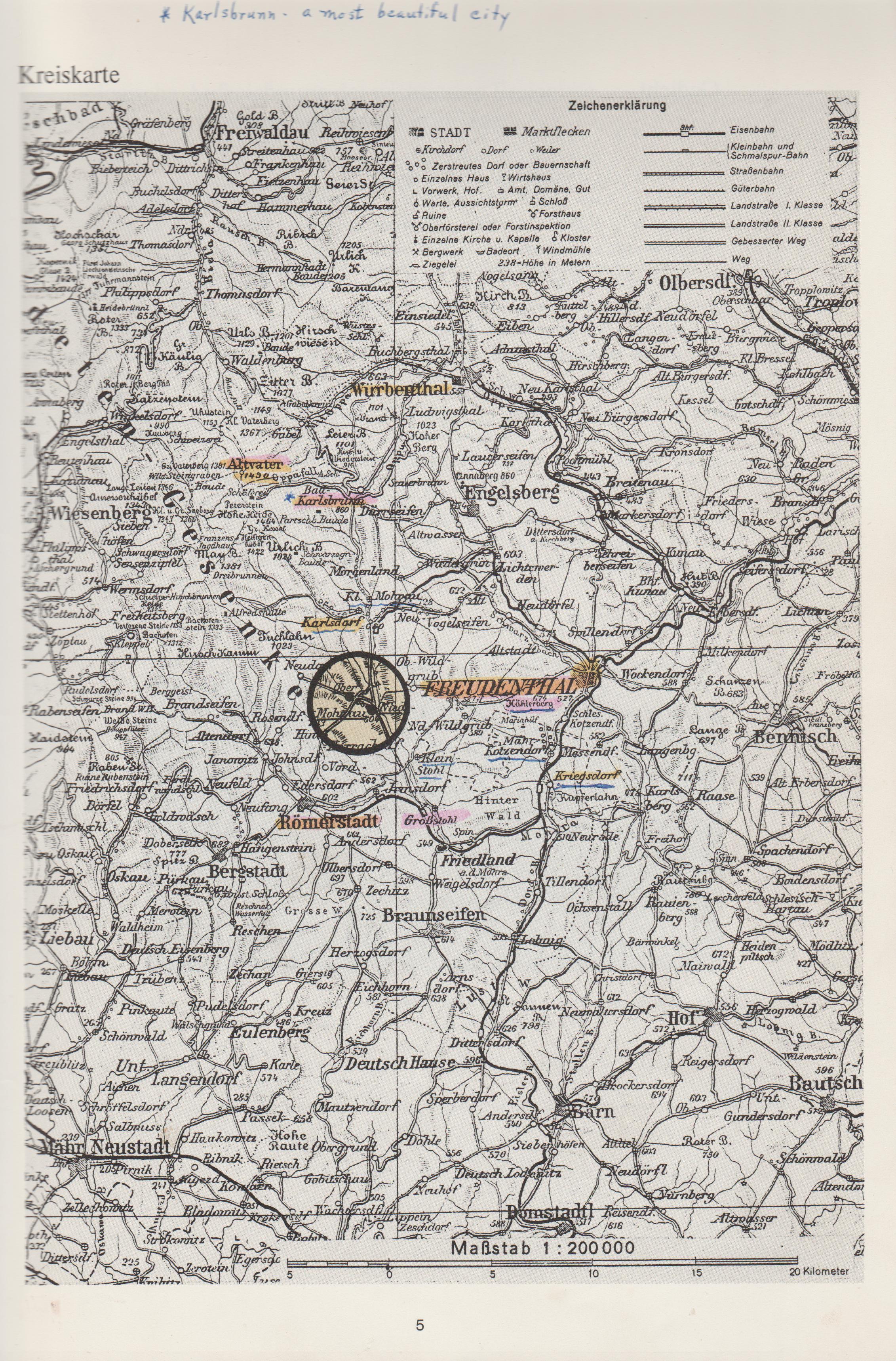 |
| Nieder- and Ober-Mohrau are circled |
This map is page 5 of the book "Unvergessene Heimat", or "Unforgotten Homeland". It is titled "Kreiskarte" which translates to circle map. That must refer to the circle in the center which marks the location of the Nieder- and Ober-Mohrau villages. To look at it closer, simply click on the image.
The areas marked in color were most likely made by Sr Agnes Beitel, Grandma's daughter who owned the book. She was probably marking important places. Some are places mentioned by Grandma in the story of her travels, some may have been places that Sr Agnes visited on one of her overseas trips. You may want to refer to this map while reading the story. The handwriting at the top of the page about Karlsbrunn was probably made by Sr Agnes. Not sure if it is a translation, or if someone thought it was a beautiful place.
You will not find these names on modern maps. As mentioned, the area is now the Czech Republic and towns have Czech names. A few I have, thanks to my cousin Linda Koenig, are:
Roemerstadt (then) - Rymarov (now)
Nieder-Mohrau (then) - Doni Moravice (now)
Karlsdorf (then) - Karlov pod Pradedem
Wurbenthal (then) - Vrbno pod Pradedem or Vrbno (now)
Along with the maps, I thought a little history/geography might be useful or at least interesting. The same book that gave the maps, also provided some history on page 9.
 |
| Page 9 with photo of a Paper mill in Nieder-Mohrau. |
As usual, I turned to my friend Al Haunold for a translation. In this case, I had sent him the page with a specific phrase or word that we had discussed. He then told me the page had interesting information and offered to tell me what it said. Here then, is his translation:
Location of our home town:
pg 9As mentioned before, our home town was founded in the year 1258. It is located in a valley between the Harrachsdorfer heights and the Teufelsberge (devils mountains), along the village creek which in Niederdorf combines with the Mohrau (river). The Mohrau river starts in a pit below the Hohe Heide and near the Rosenberge also combines with the Seifenbach. The name of this latter one leads us to the conclusion that at some time gold was panned (washed) in this creek. As all around here this location was settled as a mountainous agricultural enterprise. Its geographic details are approximately 50 degrees North latitude and 35 degrees eastern longitude.
Located approximately 6 kilometers north of Roemerstadt, Mohrau belonged to this district. The Roemerstadt district at that time included 39 communities. It was a politically recognized district with a Bezirkshauptmann (district leader) at the top. In May 1939 the district had 26,936 inhabitants. Nieder Mohrau had 804 people, meaning 248 separate house-holds, and Ober Mohrau had 308 people, corresponding to 88 house-holds, and Roemerstadt itself had 5,859 people corresponding to 1963 house-holds.
Mohrau is at an elevation of 650 meters above sea level. At the eastern edge of the town and in parts also along the Mohrau (river) is the country’s border with Silesia. Some-time later this part of Silesia and Moravia were combined as Moravia-Silesia.
According to the regular development, both villages were Reihendoerfer (villages of single-row houses) along some forested slopes, which means that behind the farmer’s houses, fields extended up to the boundary of the next village. The neighboring communities were Neudorf, Klein-Mohrau, Wildgrub, Kleinstohl, Irmsdorf, Roemerstadt, Harrachsdorf, and Rosendorf. Since our village had two streets and also two sides, the larger side and the smaller side, there were also farmer’s houses between the two sides who had their fields extending into the direction of Kleinstohl, Irmsdorf, and also toward the direction of Klein-Mohrau. With an extension of approximately 2 ½ km, Nieder – and Ober-Mohrau were typical peasant villages. The inhabitants of these locations worked in the silk-processing factories (enterprises) of Roemerstadt, in the chain manufacturing factory in Klein-Mohrau and in the Bleiche (bleaching facility) of Kleinstohl. A portion of the workers was also employed by the paper-mill in Nieder Mohrau.
Photo below: Paper-mill Matzner, Nieder-Mohrau
Next, I will continue on with Grandma's personal account.
************************************************
Story to be continued......
To read Post - "54 - Photos of Nieder-Mohrau - Click here
No comments:
Post a Comment